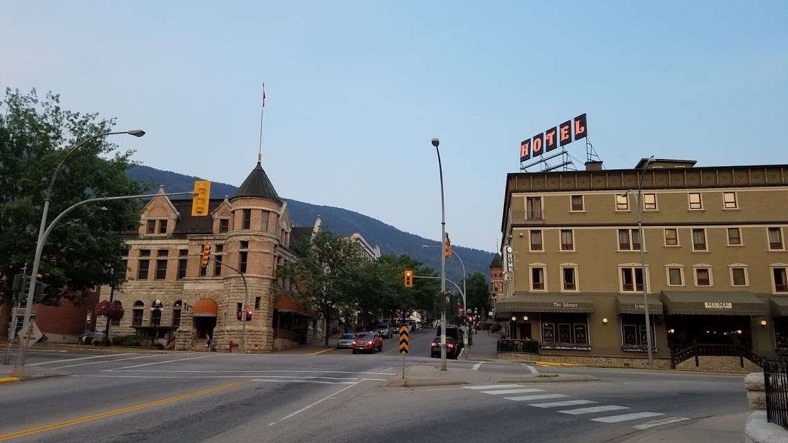
Lake Roosevelt National Recreation AreaWith the summer's end fast approaching, my wife and I decided to take one last adventure for the summer. My grandfather served as a volunteer campsite host at Dry Falls State Park and we wanted to visit him. I took the opportunity to plan one last passport stamp collecting trip with the objective of spending a night at Dry Falls and visiting my grandpa. There was terrible air quality in the northwest during this week due to forest fires in Canada and brush fires all over Washington. On top of that, the temperature was approaching 110 degrees in the area. The heat made spending a day in the air conditioning of the car and visiting different sites along Lake Roosevelt fairly appealing. Lake Roosevelt was formed by flooding from the Columbia River after the Grand Coulee Dam was built in 1941. Lake Roosevelt offers a number of recreational opportunities and features some interesting historic sites as well. We were able to visit all of the NRA's stamp locations except Kettle Falls, which is a couple hours north of the other stops. Fort SpokaneWe started the day at Fort Spokane just south of the river. Fort Spokane was a Army frontier outpost at the convergence of the Columbia and Spokane Rivers about 50 miles from Spokane. The fort had about 50 buildings at its high point and served as a military presence for about 20 years in the later 1800s. During the Spanish-American War, the military aspect of the fort was moved elsewhere and the facility was turned over to the Colville Indian Agency to serve as an Indian school for a number of years. The fort today features just a few of the original buildings and has a historic walking tour that allows you get a feel for the size and of the site while teaching you the fort's history. The museum had a number of interesting exhibits but the jail cells were particularly powerful. They had two small cells that each featured an audio recording based off the writings of Indian children that were forced to spend time in the cells for breaking various rules at the school. Indian schools are a dark stop in American history and Fort Spokane does a great job bringing this difficult subject to light. We didn't do much exploring due to the high heat and the aggressiveness of the wasps in the park. Grand Coulee DamAfter leaving Fort Spokane, we spent a couple of hours driving through eastern Washington's endless farm country. We made our way along US 2 toward Grand Coulee. We made a quick stop at Lake Roosevelt NRA's Spring Canyon area. Spring Canyon features a little campground, a picnic area, and a public beach. The ranger station here is no longer staffed permanently due to budget constraints so I was not able to get the stamp for this location. From here, we made our way to the Grand Coulee Dam. The Grand Coulee Dam blocks the Columbia River creating 150 miles of Lake Roosevelt. The dam creates power for the Columbia Basin and irrigates 600,000 acres of farmland. I had been to Grand Coulee before, but the dam is a powerful site to behold every time you visit. I had never gone in the visitor center previously and was interested to read the different exhibits and see the natural history of the area. Grand Coulee is also a part of the Ice Age Floods NGT since the coulees of central Washington were formed by the many great floods during the ice ages. After the dam, we visited the Lake Roosevelt NRA offices in town for their stamps. We did not want to take the time to go on a tour of the dam on this visit. They do a light show in the dam at night and we want to come another time to see the show and go on a tour. Steamboat Rock State ParkAn unexpected but enjoyable detour on our drive from Grand Coulee to Dry Falls was Steamboat Rock State Park. The drive south from Grand Coulee is a beautiful route along the water surrounded by cliffs carved over the eons by the river. As we made our way, we saw a sign for Steamboat Rock and made a quick pit stop. We really only drove through the park but were impressed by the views and recreation options. They had hiking trails, a campground, and water rentals. We would love to camp out here some time and head up to the dam for the night time laser light show. Dry Falls/Sun Lakes State ParkOur final destination for the day was Dry Falls/Sun Lakes State Park. I guess the name of the park has changed a few times and they have settled on having two names for the place. The Dry Falls were truly one of the most surprising and impressive things I have ever seen. I had never heard of Dry Falls before this summer and really didn't look up any pictures before our arrival. I had read up on the park but somehow hadn't seen any images. As your drive up to the visitor center, you can see nothing but rolling farmland in any direction. It isn't until you walk right up to the fence that you can see the Dry Falls. Dry Falls is a truly massive hole in the ground, something like a miniature Grand Canyon. The Ice Age Floods created water falls 3.5 miles wide, five times wider than Niagara Falls. Scientists think that it had a flow ten times greater than all the current rivers in the world combined! I was really quite blown away by the view and very pleased to learn that the state park was at the bottom of Dry Falls and that we were about to spend the night at the bottom. Dry Falls is part of the Ice Age Floods NGT so we picked up our stamps and then headed down to visit with my grandfather for the night and cool off in the lake. We camped out here and did a little paddle-boarding before heading off the next day.  New Units Visited: 1
Lake Roosevelt NRA Total Affiliated Areas This Year: 20 Total Units: 29
0 Comments
Ice Age Floods National Geologic TrailMy biggest goals within the National Parks Passport program in the short term are to visit all of the NPS units in Washington state (hopefully in the summer of 2019) and to complete the entire Ice Age Floods National Geologic Trail. This trail is comprised of a number of sites in the northwest centered around the Missoula Floods after the last ice age. Glacial dams in Idaho and Montana gave out and released massive flooding across Washington and Idaho, emptying large inland seas across the continent. These floods have always interested me since they explain many unique geologic features in Washington state. My first stop on this trail was Turnbull National Wildlife Refuge, only a 45 minute drive from my house and the only stamping location that close to my new home in Spokane. I had recently accepted a teaching position for a local school district and needed to drop off some paperwork at our offices, and decided to make a day out of it and visit nearby Turnbull. The Channeled Scablands of Turnbull were created during the great floods of the last ice age. The area is unique for its mixture of basalt outcroppings, flooded channels, and pine forests. The wetlands are a great breeding area for water fowl and, for this purpose, a protect wildlife area. My wife and I stopped by the visitor center to ask about what birds we might see during the summer time and to pick up my stamp. They have a cool refuge stamp featuring a bat that is unique compared to the typical NWR stamp featuring a goose. We then set off on the driving tour of the refuge. It was over 100 degrees that day so we limited our hiking to a minimum but we did make a couple of stops to look for birds in the wetlands. Turnbull was a cool place to visit and I am excited to check it out again in the spring when the water fowl are more active in the area. New Units Visited: 1
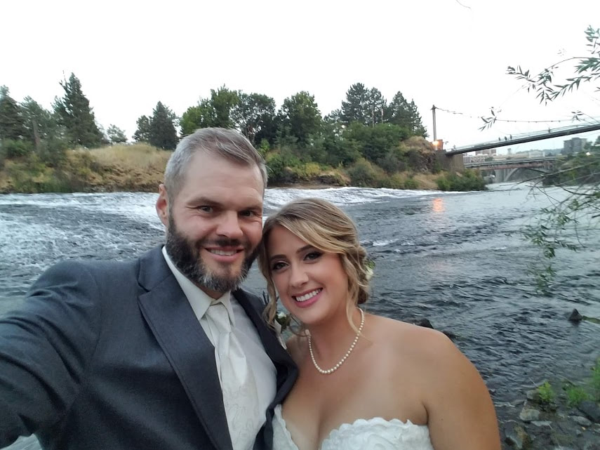
Ice Age Floods National Geologic Trail Total Affiliated Areas This Year: 19 Total Units: 29 North to CanadaWe continued our adventurous summer with a brief honeymoon in British Columbia, Canada. I planned us a road trip based around completing the International Selkirk Loop Scenic Drive. This route takes you through Washington, Idaho, and British Columbia. We spent the bulk of our time in Nelson, BC, a small historic city with an artsy international vibe. We stayed at a nice hotel on Kootenay Lake and sampled the different breweries in Nelson. We spent a day at the Ainsworth Hot Springs, about an hour north of Nelson. The hot springs are well worth a visit if you are ever in the area. They have a hotel, which we did not stay at, and a hot springs pool overlooking the lake. The hot springs also feature a cool cave in which you can experience the springs in their natural environment. After our stay in Nelson, we completed the Selkirk Loop and spent a day driving along Kootenay Lake. The highway requires passage on a ferry across the lake, which was a fun way to spend an afternoon. We made our way down the Selkirk Loop until we finished the loop, then headed south into Sandpoint, ID. This small lake town has become a tourist destination over the years and features a vibrant downtown. My mom grew up in Sandpoint and I spent many summers as a child in the town and on the lake here. We stopped for a quick drink at a local brewery and then headed back to Spokane. July 28, 2018 was finally the big day: our wedding! My wife and I got married in the University Chapel on campus of my alma mater, Gonzaga University. We had a beautiful reception in an old flour mill on the Spokane River. It was an amazing day and am opportunity to celebrate and catch up with friends and family. In July, I helped a friend move from the Ventura, CA area to Spokane. He took me to lunch at a restaurant in the Ventura harbor which happened to be right next to the Robert J. Lagomarsino Visitor Center at Channel Islands National Park. I popped in to check out their exhibits and pick up their stamp. I didn't really visit the park itself so I did not do a full right up, but it did count toward my quest for 25 units this year so I am including my stop here. New Units Visited: 1
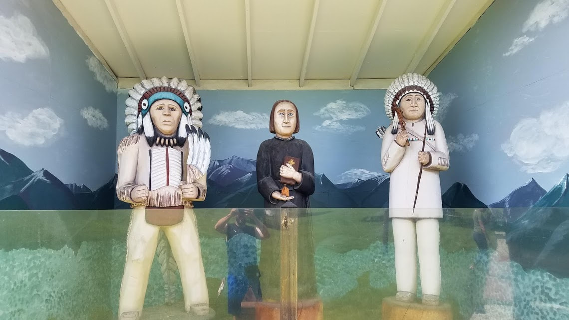
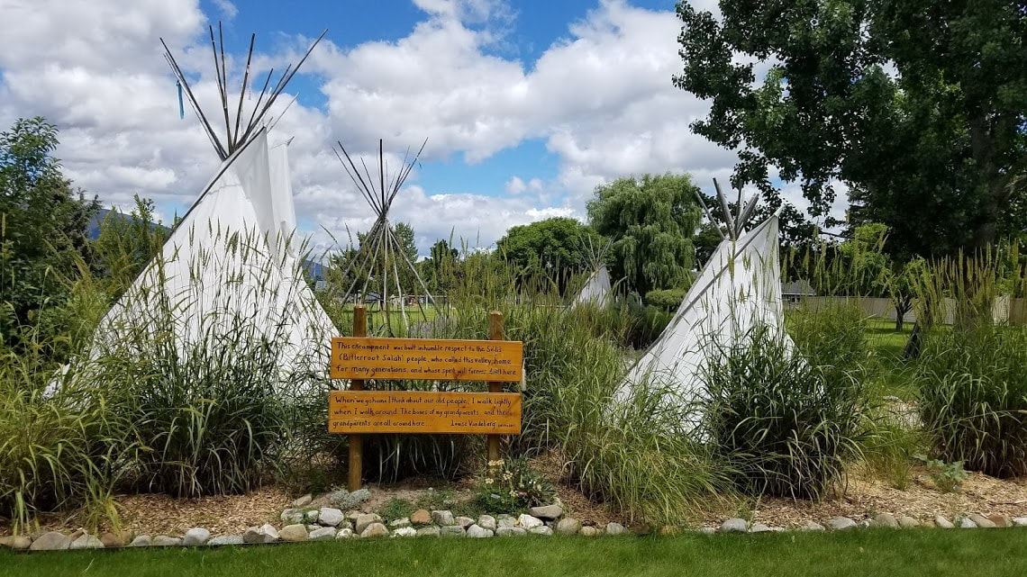
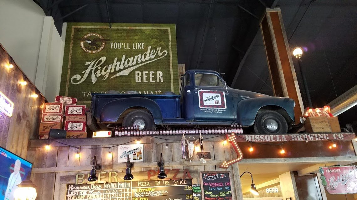
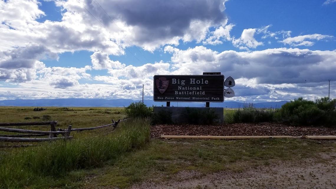
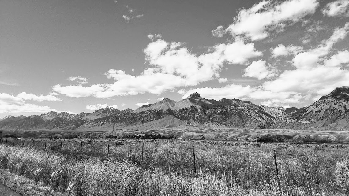
Channel Islands National Park Total Affiliated Areas This Year: 24 Total Units: 32 Bitterroot Valley, MontanaFollowing a nice morning at Big Hole National Battlefield, we hit the road for the final stretch of our adventure to our new home and lives in Spokane, WA. There were a few stops in Montana that were on my National Parks passport list but timing was not on our side. The Ravalli County Museum in Hamilton has passport stamps for 3 different National Historic Trails and looked really interesting on their website. Time was not on our side though, they are closed on Sundays and that happened to be the day we made our way through the area. There were also a couple of stamping locations near and in Missoula but we decided to pass on these as well. We had been on the road for almost a week at this point and were close enough to home that we made the choice to push to the finish line with just a few quick stops. I went to Catholic school my entire education, including Gonzaga University. This back ground has led to an interest in the history of early Catholic missionaries in the west and, in particular, the early Jesuits missionaries. St. Mary's Mission in Stevensville was just a 5 minute detour from our path so we stopped for a brief visit. The mission was founded by Father Pierre De Smet, for whom a building at Gonzaga is named. The mission is a quaint and beautiful little area nestled against a mountain backdrop. We took a quick walking tour of the historic buildings and displays they have up for guests. The mission was one of the earliest white settlements in Montana and the west. The mission worked with many of the native tribes of the area and still offers some services today. We next stopped in Missoula for lunch and a beer at Highlander Brewing. My fiance and I love to visit small breweries anywhere we travel and Missoula is a great beer town. Montana has a brewery passport program for anyone that plans on visiting the many breweries in the Big Sky State. Idaho Panhandle and SpokaneAfter lunch, we hit I-90 west in Missoula and headed for home. The drive between Missoula and Spokane features a brief visit to the Idaho panhandle. We stopped to stretch our legs and visit another brewery, Wallace Brewing Company. Wallace, ID, the self-proclaimed "Center of the Universe" is a historic mining town resting between the mountains in the Silver Valley. We had visited Wallace once years ago but were excited to wander the streets and visit WBC. Breweries in eastern Washington and north Idaho have a passport program called the Inland Northwest Ale Trail. I had started collecting these stamps during various visits to Spokane over the last few years and wanted to get the Wallace Brewing stamp as something of a welcome home present to myself. Home at lastA little over an hour later we were finally in Spokane and our new home! June and July were going to be major moments in our lives as we moved, looked for jobs, started school, and got married. I went to college in Spokane and my fiance had grown up there. We were excited to get to town and start our new lives and adventures together. Our road trip north continued in the morning as we headed up US 93 from Salmon into the mountains and Montana. Lost Trail Pass marks the border between Idaho and Montana and the turnoff for Big Hole National Battlefield. I found the history of the battle and the Nez Perce Flight of 1877 fascinating. I have always felt that Native American history is ignored in most history classes and in our culture. I will detail a brief history of Big Hole as I thoroughly enjoyed my visit and learning the tragic history of the Nez Perce. In August of 1877, over 800 nimí·pu (Nez Perce) were camping along the Big Hole River in the Bitterroot Valley. The Nez Perce had crossed into Montana in hopes that the US military would not pursue them. The government had begun to force the Nez Perce out of their ancestral lands and the group at Big Hole had hoped to avoid being relocated to a reservation. The battle began when the US Army fired upon the sleeping camp, killing a number of women and children. The battle raged for 2 days with the nimí·pu having some success, they captured an Army Howitzer and attacked the soldiers. When the battle had ended, 60-90 nimí·pu had been killed along with over 30 soldiers. This was a major turning point for the Nez Perce. They no longer believed that peace could be reached with the Americans and they continued to flee the Army until October of 1877 when Chief Joseph surrendered. Big Hole NB was a beautiful place to visit. We stopped at the park early in the morning, just as it was opening for the day. The visitor center has great sweeping views of the river and the valley. The center had some nice displays and we watched a bit of the video (although I soon realized that it was the same video I had watch on YouTube the week before). From there, we decided to check out the hiking trails. They have a few trails at Big Hole and we walked 2 of them during our visit. The Siege Area Trail takes you up into the hills where the warriors besieged the soldiers. There is a monument to the Infantry soldiers and a nice little trail to an overlook that gives a great view of the valley and the camp area. We ran into out old nemesis, bees, so my fiance skipped the overlook and we decided not to risk the Howitzer site. We had a little more time so we also walked the Nez Perce Camp Trail. This was a peaceful, flat, hike along the river to the camp site. They have a number of tent poles recreated to show what the camp might have looked like at the time of the battle. Overall, Big Hole is a beautiful place and experience. I could really feel the sacred quality of the land and the spirits of those that died there. It is important to understand our history, especially the parts that are ugly and difficult to talk about. Big Hole is a must visit to help us all understand the loss and sacrifice peoples and cultures made while the US expanded west. New Units Visited: 3*
Big Hole NB - Nez Perce NHT - Lewis & Clark NHT Total Affiliated Areas This Year: 18 Total Units: 28 For the sake of time and distance, we decided against camping out at Craters of the Moon and headed north on US 93 with the goal of finding a campsite or hotel in the Salmon, ID region. The drive along US 93 through north-central Idaho runs along the Salmon River in narrow valleys surrounded by mountains and National Forest land. The Salmon River Scenic Byway was a fun drive, winding with the course of the river for about 60 miles. We made the drive around 5 pm and the bugs were out in full force. Our car was more covered with bug guts than any I had ever seen! For this reason, we decided against finding a campsite and made our way to Salmon to find a motel. Naturally, the last weekend in June is Salmon River Days and the town was packed with visitors. We lucked out and found what might have been the last hotel room in town. We stayed at the Stagecoach Inn right along the river. We spent a little time wandering along the main street of town and settled in for dinner at a small local brewery. The food and beer were both great and the town was a fun place to spend a night. We spent the rest of the evening lounging in the hotel hot tub watching some deer pass by on ridge over looking the hotel and river. If you are ever in the area, Salmon, ID is worth a visit. Shoshone FallsWe had camped out the previous night at a hot springs RV park south of Twin Falls, ID. We were continuing our slow journey north as my fiance and I were moving from LA to Spokane, WA. We had spent the previous day in Great Basin NP and had plans to visit a few different locations on this day. Our first stop, bright and early in the morning, was Shoshone Falls. Located on the Snake River on the outskirts of Twin Falls is Shoshone Falls Park. After paying the $3 entrance fee, you drive down a windy beat up road to a bluff over looking the river. Shoshone Falls was a striking sight. Shoshone Falls is a taller drop than Niagara Falls and it is easy to imagine how impressive an experience they must be when the river levels are high. We visited in late June so the amount of water was not tremendous but the falls were still worth the quick stop. We took a brief walk to a small lake that is part of the park and did the loop trail there. The Snake River gorge and the falls were beautiful, a park that I would like to see again under more ideal conditions. Minidoka National Historic SiteFrom Shoshone Falls we headed north to Minidoka National Historic Site. Minidoka is not far from Twin Falls, just outside Jerome, but it has the distinct feel of being isolated, which is probably why the site was chosen to be home to an internment camp. From 1942-1945, Executive Order 9066 authorized the removal of Japanese Americans from their homes and relocation to camps in remote areas of the American west. Minidoka is not the most well known of these camps, but the area housed thousands of men, women, and children during WWII. The site seems to be incredibly small and almost non-existent at first sight. You come across a reconstructed guard tower and the remains of a guard station along the road. There are, literally, two parking spaces and a couple of informational signs. I knew there was a temporary visitor center a little ways up a gravel road but I was beginning to worry that this was all there was to see. Luckily this impression was wrong and there ended up being plenty to see. There is a 1.6 mile trail that circles the NHS site and features the relics of authentic buildings, recreations of camp sites, and visuals of the impact the camp had on local farming up to today. There were signs along the trail detailing what each area looked like during the war. One of the coolest parts of the site was the baseball field. I have read stories from multiple Japanese internment camps about how baseball helped people survive their imprisonment. Minidoka had 14 baseball and softball fields during the war and the site has reconstructed a field, now called Center Field. The visitor center described baseball as "a glue" that helped keep people together during internment. I have coached youth sports for a number of years and truly believe that athletics can unit people and help you grow as a person. It was awesome to see a piece of sports history in the midst of remote Idaho farm country. The only real drawback of our visit to Minidoka was the bees. The trail was completely overrun by ground nests of nasty wasps and bees. The area near the river was the heaviest concentration of buzzing creatures I have ever experienced. There was also quite a large colony near the baseball field. This doesn't really bother me, but my fiance is deathly afraid of bees and was quite shaken up by our experience stumbling across the massive grouping of wasps. We retreated to the temporary visitor center to recoup from the bees and pick up the park's stamps. They are doing some remodeling and work at the site and the visitor center is currently in a WWII-era house a short walk from the trail. The exhibits were interesting and a great reminder of the horrors of war. Minidoka also has a memorial site on Bainbridge Island, near Seattle, that I hope to visit in the near future. Minidoka NHS is well worth the drive if you are ever in the area; although be prepared for bees! You can take in everything in as little as an hour. We visited the park nice and early in the morning because we were also planning on visiting Craters of the Moon that afternoon. New Units Visited: 1
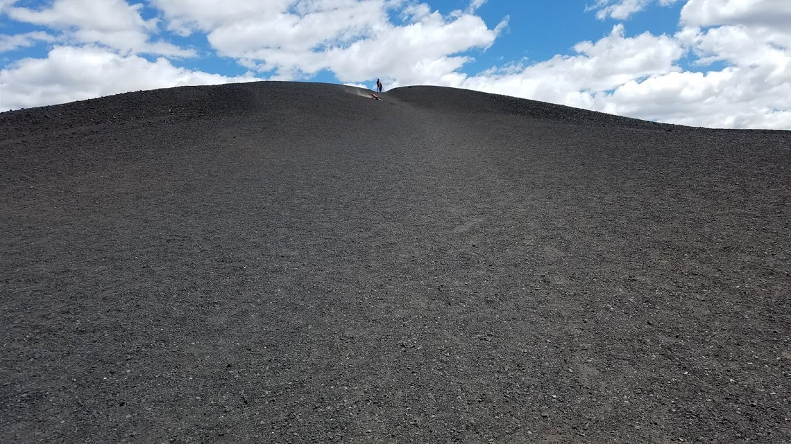
Minidoka NHS Total Affiliated Areas This Year: 12 Total Units: 25 Walking on the surface of another planetAfter surviving the massive swarms of bees and wasps at Minidoka, we traveled 90 miles northeast to Craters of the Moon National Monument and Preserve. I have vague memories of visiting Craters of the Moon as child with my family and leaning over a cinder cone to see snow inside the opening of one of the volcanoes. I shared these memories with my fiance as we first began to pass by the charred lava landscape of the park along the highway. From the road, jagged volcanic rock and a number of cinder cones are visible. Craters of the Moon truly looks like the surface of another world. The lack of vegetation and scarred landscape are unlike any other part of America that I have visited. We pulled into the visitor center to pick up some information, maps, and the stamps for the park and for the Oregon National Historic Trail. Craters of the Moon has a number of caves that visitors are welcome to explore on their own but you must check in at the VC to receive a cave permit. They want to make sure that any clothing you are wearing, or your shoes, are free of diseases found in other caves. My wife had to dig an extra pair of shoes out of the car before we got to the caves since the shoes she was wearing had been in the Lehman Caves at Great Basin a couple of days before. The VC was nice and there was a ranger with a telescope allowing for guests to view the moon. Craters of the Moon, like Great Basin, is an International Dark Sky Park. From the VC we took off on the Loop Road, which travels in a big circle to each of the most visited sites in the park. We made our first stop at the Devil' Orchard Trail, a 0.5 mile paved trail of cinder beds along a crater wall. This trail features a series of signs describing the difficulties of preserving the fragile volcanic environment. We next stopped at the Inferno Cone. This cinder cone features a steep trail up the side of the cone that ends with panoramic views of the area. The trail is only about a half mile but is a steep climb. The views at the top were worth the climb and its not everyday that you get a chance to hike up the side of a volcano. We next visited the Splatter Cones, which were the formations I remembered from my childhood visit to the park. These were a collection of small volcanoes that formed from blobs of molten lava the splattered from nearby cones thousands of years ago. It is a brief walk from the parking lot up these small cones. You can look down into the mouths of these once active volcanoes, one of which features snow throughout the year. From here we headed to our last stop, the Caves Trail. It is about a mile hike to the largest and most accessible cave, Indian Tunnel. My fiance decided to skip the caves so I ventured solo into the darkness while she rested topside. There are large openings on two ends of this cave so there is a decent amount of light throughout a large portion of the cave. I climbed over some rocks and made my way to the far end of the cave where I was able to work my way through complete darkness for a few minutes to the end of the cave. I spent about 20 minutes exploring before heading back toward the trail. We stopped at one more cave before leaving, the Dew Drop Cave. This cave required far more climbing and featured very little light. There were two other caves down another branch of the trail that we decided to pass on seeing. One of the other caves is called the Boy Scout Cave, supposedly because the entrance is so narrow that only a Boy Scout can fit through it. After the caves, we paid the visitor center a second visit to check out the gift shop and refill our water bottles. We weren't entirely sure where we would stop for the night but decided to head further up the road since we had accomplished everything we had wanted to see at Craters of the Moon. We paid a brief visit to the small town of Arco, ID, a brief drive to the east of Craters of the Moon. It was interesting to discover that Arco was the first community in the world to be powered solely by nuclear energy. From Arco, we headed north in US 93 along the Salmon River. New Units Visited: 3*
Craters of the Moon NM&PRES - Oregon NHT Total Affiliated Areas This Year: 15 Total Units: 27 |
NPS Units:
|


 RSS Feed
