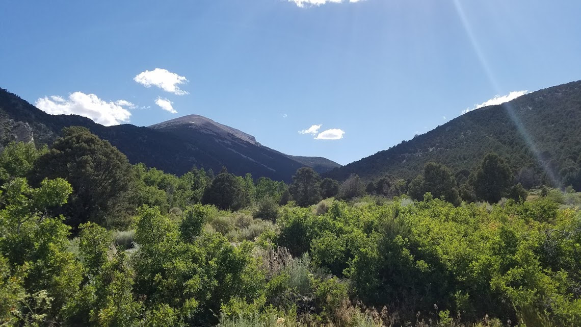
The first National Park of my adventuresAfter our drive past Area 51 and a few hundred miles of empty desert and range land, we began to climb in elevation in our approach to Great Basin National Park and Great Basin National Heritage Area. About a half hour outside of Ely we entered the tiny town of Baker, gateway to Great Basin. I stopped by the offices for Great Basin NHA to pick up their passport stamps and to get some information. The woman there gave me an awesome "Loneliest Highway" bandanna since I did not have a copy of that passport book and told me about a planned digital passport app for the heritage area program. The heritage area covers a large portion of Nevada and Utah in the Great Basin and is home to a number of museums and natural sites. I was considering visiting the Baker Archaeological Site about 5 miles from the NHA office. The site is home to a filled in Indian village archaeological dig that sounded interesting (Unfortunately, we never made it to the site due to time constraints). The NHA office was a stones throw away from the Great Basin NP Visitor Center. The VC is located on the highway just outside the park's main entrance. We took a look around the exhibits and spoke with the ranger about campground options in the park. While I was picking up my stamps, the rangers were able to hook me up with a "Loneliest Highway" passport book which was fun to flip through. The main visitor center is home to a slice from Prometheus, the oldest known tree at its time. The tree lived for 4,900 years with the Great Basin before its demise. Despite the unfortunate end of this ancient tree, it was amazing to see the seemingly endless rings of the tree slice. We picked up a few things from the gift shop, grabbed our map, and headed into the park to find a campsite. It had been a long day of driving so we decided to skip any hiking that evening. We were looking forward to the ranger-led astronomy program that night so we rested up at the campsite for a few hours. We made our way down to the Lehman Caves Visitor Center about an hour before the astronomy program. This VC is located within the park and is just outside the Lehman Caves, which we had booked a tour of for the next morning, I picked up my stamps and then we wandered around the short interpretive trail before finding a good seat for the astronomy program. The program was interesting and began at dusk with a presentation projected on to a screen in the parking lot. The sunset in the parking lot featured a gorgeous sweeping view of the basin and Wheeler Peak. I was excited for nightfall and the start of the program. Great Basin is a designated International Dark Sky Park and is known for its tremendous night sky. Of course, the night before our visit was a full moon and our views of the stars were limited due to the light of the moon. This did not take away from the great information provided by the rangers but we did miss out of the full Great Basin dark night experience. The program ends with opportunities to look through telescopes at different features of the sky and the Milky Way. The moonlight made this pretty uneventful so we called it a night and headed back to our tent to rest up for our cave tour and planned hikes in the morning. Lehman CavesOne of the coolest features of Great Basin is the Lehman Caves. The caves wind into the hills and mountains behind the visitor center within the park. They offer a 60 minute and 90 minute tour, both of which often sell out so you should buy your tickets ahead of time online. We had a 9:00 am tour time and checked in early to make sure we were compliant with White Noise Syndrome policies. The parks service works to protect bats within its caves by asking guests if the clothes and shoes they are wearing have ever been in another cave in the past. They are working to prevent the spread of disease and protect bat populations. The tour begins at the visitor center and heads into a large cavern at the entrance of the caves. I volunteered to bring up the rear of the group and carry an official flashlight. The ranger did a great job of explaining the natural features and history of the caves. The caves have been a tourist attraction for over a hundred years and used to be a social gathering place. A nearby high school actually held their prom in the caves for a number of years in the past. The caves were a popular place to party and drink during prohibition. These various uses have led to types of vandalism and damage that the park know preserves as a part of their history as the caves slowly rejuvenate themselves. There were a few points in the tour that we turned off all of our light to get a feel for the natural darkness of the caves. It is amazing to picture people touring the caves by candle light in formal attire 80 years ago. The tour was great and my fiance was happy to have visited her first cave. Wheeler Peak and Bristlecone PinesAfter our cave tour, we ventured 12 miles up the steep and windy Wheeler Peak Scenic Drive to the main hiking area of the park. Wheeler Mountain is the second highest peak in Nevada and home to many bristlecone pines, a variety of tree that lives to incredibly old ages. The scenic drive takes you toward the top of the mountain and the last campground of the park. A series of trails begin at or near the parking lot at the end of the drive. We elected to take on the Bristlecone and Glacier Trail hike to capture some of the highlights of Great Basin NP. The trail was listed at 4.6 miles, but with a few detours we ended up completing about 6 miles at around 10,000 feet of elevation. The elevation definitely hit me for the first few miles but not enough to take away from the amazing setting and scenery. We detoured to the small alpine Teresa Lake and then worked our way to the bristlecone pine grove. This is a short loop through a heavy congregation of the gnarled and warped pines. These trees were interesting for their variety and unique features. No two bristlecones were the same as each tree had its own features. From the pine grove, you can turn back toward the trail-head or continue on the glacier trail. I was not going home until I saw a glacier in Nevada! I have been to the Las Vegas area many, many, times and spent quite a bit of time driving through the desert of Nevada and California. The fact that there is a glacier in Nevada blows my mind. I know that Nevada features different geography and natural features besides desert, but a glacier just was not something I imagined finding within a few hours drive of Las Vegas. The hike to the glacier was difficult due to the altitude but worth it. The glacier is nothing too terribly exciting, a rock and snow pile nestled near the top of the mountain, but the views of the surrounding peak were well worth the trek. We hiked our way back to the car and then began the drive down the mountain. We payed the Lehman Caves Visitor Center one last visit, refilled all of our water bottles, and hit the road. Exiting Great Basin, we headed north on US 93. We planned on camping out near Twin Falls, ID for the night. Northern Nevada was about as desolate and the rest of the state but had some interesting features. There was a long stretch of highway that was surrounded by large fences designed to funnel game animals toward a series of animal crossing overpasses over the highway. I had seen pictures of similar overpasses online but had never seen one in person. The BLM office in Vegas had described the large quantities of elk and other game animals that migrate through the area and I am glad that the state has some systems in place to protect the migrating and traveling creatures. The entire drive the Nevada was amazing. Despite the isolation and lack of population centers, the natural features and changing scenery made for a fun and relaxing drive. New Units Visited: 2*
Great Basin NP and Great Basin NRA Total Affiliated Areas This Year: 11 Total Units: 24
0 Comments
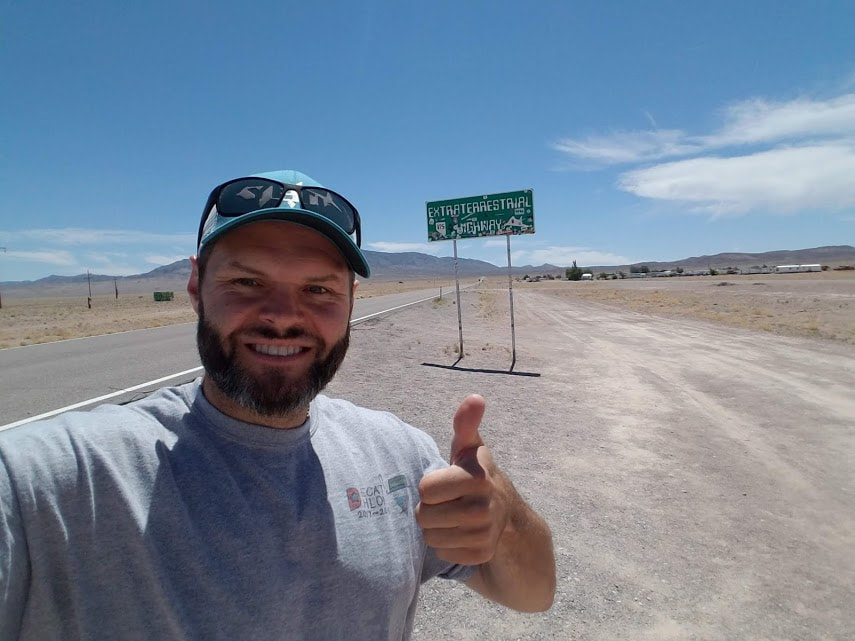
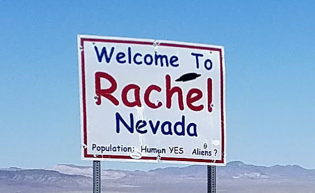
A journey that was...out of this worldAfter our final night in Las Vegas, we hit the road for Great Basin National Park. We decided to take the scenic route and travel The Extraterrestrial Highway, Nevada State Route 375. This route takes you deep into the heart of the Nevada desert and as close to the infamous Area 51 as the government will allow. The most direct route to Great Basin would take US 93 north the entire route. We did travel on US 93 on our way to NV 375 when, through the seemingly end miles of desert, we stumbled upon Pahranagat National Wildlife Refuge. I had seen Pahranagat on the map and grabbed a brochure at the Las Vegas BLM office but was blown away by the sudden appearance of a green oasis and lake in the midst of the Nevada desert. We exited the highway and drove around the refuge for about 15 minutes. The visitor center is only open on the weekends during the summer so we could not pay a visit but I walked around the surrounding area where they had some informative signs and a brief interpretive trail. The refuge was a beautiful respite from the harsh desert landscape. We returned to the road and arrived in Crystal Springs about 30 minutes later. Town is a strong word when describing the cluster of a few small buildings. Crystal Springs is the official start of The Extraterrestrial Highway and NV 375. You know you are approaching ET territory when you see large signs for ET Fresh Jerky and a large metallic alien statue outside a building called the Alien Research Center. Nevada State Route 375 was officially renamed The Extraterrestrial Highway in 1996 in an effort to attract travelers. The area is famous for its proximity to Area-51, a top secret Air Force facility where many strange aircraft have been sighted. I read online that as few as 200 vehicles travel the road on any given day. You absolutely feel the isolation and have a sense of being completely alone with just the road ahead of you. We saw very few cars pass by us traveling the other direction and I don't know that I saw any cars in my rear view mirror at any point. The area around the highway is open range and we did see cattle lounging on the road a few times. The only real points of interest along the path are the road to Area 51 and the tiny town of Rachel, NV. About a half hour before you get to Rachel, you will pass a dirt road heading off a great distance toward the west. The road is far too well maintained to be a rancher's driveway and, according the people in Rachel, is the road to Area 51. Rachel is home to the Little A'Le'Inn, a small restaurant and inn. We stopped at the Little A'Le'Inn for lunch and to take a break from driving. The food was pretty good considering you are at a dive bar 100 miles from the nearest gas station. We talked briefly with the waiter and perused their wall of souvenirs for sale. We picked up a few bumper stickers and they even had a cool stamp for my passport book. We bid farewell to the Little A'Le'Inn and continued our long trek north. The Extraterrestrial Highway ends in Warm Springs at the junction with US Highway 6. Here we turned northeast toward Ely. NV 375 was well worth the detour. The drive is stunning and a great chance to truly feel disconnected from the world. Around 2 and half hours after leaving Rachel we entered Ely, NV. Ely is a decent size town with a cool main street cutting through town. We stopped to stretch our legs and wandered through one of the old casinos. I discovered that Nevada has its own passport program for Highway 50, "The Loneliest Road in America." I was able to pick one of these "Survival Guides" at Great Basin and picked up a few stamps. From Ely we headed east to Great Basin, about an hour away. Our big move to WashingtonThe summer of 2018 was to be a key period in my life thus far. I was getting married in July and we were moving from Los Angeles to Spokane, WA to started our new married lives. I had accepted a job at a middle school in the Spokane area and my future wife was eager to go back to school full-time. We figured we might as well get all of our major life changes out of the way in one fell swoop. The day I wrapped up school for the year, we packed a trailer and hauled all of our possessions up to WA before heading to my cousin's wedding and visiting San Francisco. We had a few loose ends to take care of in LA and then we were set to drive my wife's car up north and start our new lives. This gave me the opportunity to plan a 1,500 mile road trip designed specifically to see amazing new sites and fill up my National Parks Passport. We were going to drive from LA to Las Vegas, head north to Great Basin NP and then through Idaho and Montana before arriving in our new home in WA. I will break down the trip based on the stops we made each day. Red Rock Canyon NCALiving in LA, we made it out to Vegas on a fairly regular basis for weekend getaways, to visit my family in the area, or to catch an event. We have ventured all over Las Vegas but had never made it out to Red Rock Canyon National Conservation Area. We stayed 2 nights at the Aria on the Strip and planned one of our two days in town around the valley's natural areas. We got up early and drove out to Red Rock where we put our new America the Beautiful Pass to work for the first time. Red Rock is run through the Bureau of Land Management but is connected to the NPS service through the Old Spanish NHT. Red Rock has a beautiful visitor center just inside the entrance station that has some indoor panoramic viewing areas, in case the desert heat is too much to go out and explore. The main area of Red Rock Canyon is based on a one-way 13-mile scenic driving route that winds throughout the park. The scenic drive has a number of parking lots and trail-heads that allow for you to get out and see the landscape up close. We arrived early enough that we could go on one good hike before the summer heat became too much to handle. We chose the Calico Tanks trail as it was supposed to be moderately strenuous while having a taste of all the different elements that make Red Rock Canyon special. We climbed over smooth red rocks, up stone staircases, and past large agave plants. We also made a stop at the brief Petroglyph Wall trail. This cliff-side features great examples of Native American wall art and dates back as much as 800 years. The Petroglyph Wall is a short walk from a parking lot near a picnic area and is well worth the brief stop. Red Rock Canyon was an awesome place for a morning hike and we would love to make it back here some day to try out some of the other trails. I love the desert and its harsh landscape and Red Rock is an awe-inspiring place for desert scenery. From Red Rock Canyon, we made a large driving loop around Las Vegas to make a quick drive by Desert National Wildlife Refuge and Tule Springs Fossil Beds National Monument. My research indicated that these areas are not well developed and we were not ready to go off-roading through the desert in a Honda Civic so we just made a short pass. I made a stop at the Southern Nevada District Office for the BLM to pick up their stamps and get some information about points of interest north of Las Vegas. The woman at the entrance desk was friendly and helpful. We then headed to Walmart to stock up for the rest of our road trip which would feature far more campsites than it would luxury resorts. After a fun morning taking in Las Vegas' natural side, we ventured back toward the Strip and the man made wonders for which Vegas is better known. New Units Visited: 1
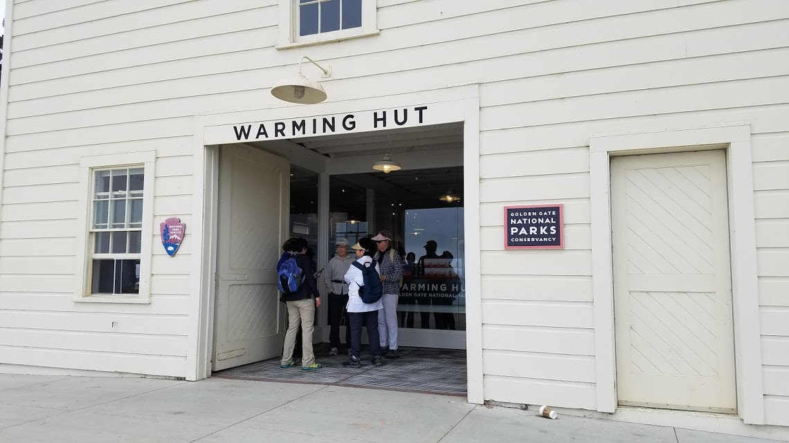
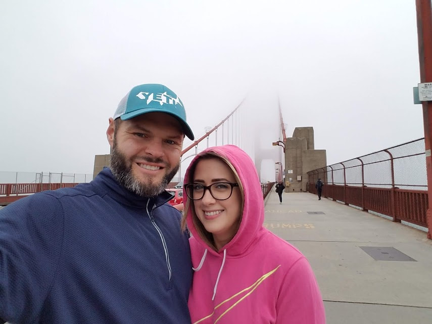
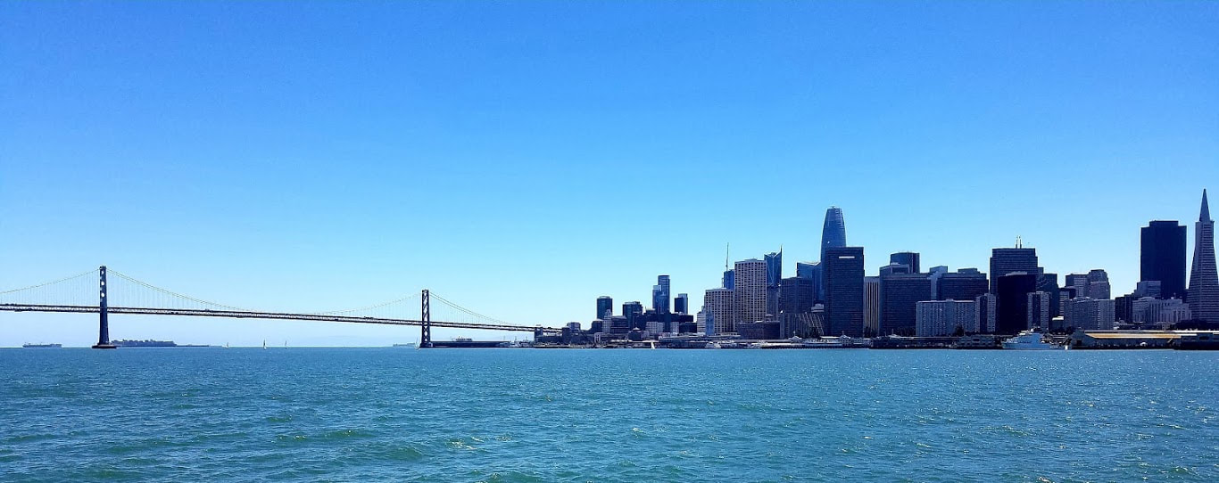
Tule Springs Fossil Beds National Monument Total Affiliated Areas This Year: 9 Total Units: 23 I have been to San Francisco a couple of times in the past but was excited to return now that I have begun my National Parks quest. My cousin was getting married in the San Jose area but we decided to come to town a little early and spend a day visiting San Francisco's NPS units. We flew into town int he evening and made our way to our hotel near Fisherman's Wharf in San Francisco. We wandered around the Ghiradelli Square area and then grabbed a bowl of clam chowder at Boudin Bakery. I am a sucker for clam chowder in a bread bowl! We then called it a night so that we could get an early start in the morning. Golden Gate NRAAfter breakfast at the hotel, we caught an Uber to the Golden Gate Bridge and the Welcome Center for the park. I picked up the stamps there and we talked with the ranger and grabbed a map. We found out that Fort Point was closed that day so we weren't able to check that out on this trip. We started out on the Golden Gate Bridge itself, walking out about a third of the way across. It was a classic bay area foggy morning which allowed for some cool pictures of the bridge masked in the clouds. After the bridge, we walked along the coast on the San Francisco Bay Trail to the Crissy Field Warming Hut. From here we continued along the trail and walked along Crissy Field itself. I was not familiar with the aviation history of the area and it was interesting to see the old airfield and hanger buildings that are finding modern uses. At the end of the former airfield is a marsh and wildlife area. We saw some amazing birds feeding in the wetlands. We next made our way up to the Presidio and the visitor center there. We did a brief lap around the old parade grounds before heading back to the bay trail. We stopped by the Crissy Field Center for one last stamp (they were closed but mailed me a stamp!) and visited the wave organ jutting into the marina. This marked the end of the trail along the bay but we continued our walked back toward our hotel. We made our way to Fort Mason which serves as the headquarters for Golden Gate NRA and San Francisco Maritime NHP. The headquarters were closed for lunch when we arrived and we were not able to stick around due to time constraints. This was a little disappointing since I have heard that the HQ is a treasure trove of NPS stamps. San Francisco is also a part of the Juan Bautista de Anza NHT, as de Anza's journey ended with his founding of San Francisco. This trip along with my previous days in LA brings my total stops along this trail up to 6. San Francisco Maritime NHP and Ferry RideAs I mentioned, we were in the bay area for a wedding which included a family dinner in San Jose that evening. This meant that we had a deadline to catch the ferry over to Oakland and meet up with my family. The only real rush we felt during the day was at San Francisco Maritime NHP. We really did not have time to explore this park in any real way. We were able to quickly walk by the ship and do a brief pass through the museum while I picked up the stamps for the park. The Maritime Museum is located in an old bathhouse building. I grew up near the Port of Los Angeles which has its own maritime museum in an old ferry building; I thought the two buildings looked pretty similar. After a quick pass through, we made our way back to our hotel to grab our bags and then caught the ferry from Fisherman's Wharf to Oakland's Jack London Square. From there, a friend picked us up and we went to our family dinner and the wedding festivities began. New Units Visited: 2
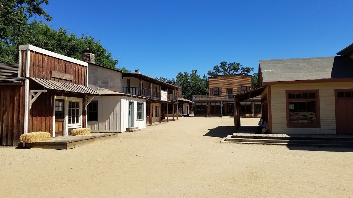
Golden Gate NRA - San Francisco Maritime NHP Total Affiliated Areas This Year: 8 Total Units: 22 UPDATE: The Woolsey Fire in November 2018 has swept through the area and burned a large portion of the NPS land in the Santa Monica Mountains. On top of this, Paramount Ranch has been completed destroyed. This is unfortunate but seems to be the way things are headed in California with increasing wildfires each year. I am glad I spent this day in the area prior to these fires.LA's National Parks LandThe Santa Monica Mountains National Recreation Area stretches along the coast just north of Los Angeles inland toward the city itself. I have been hiking in the area multiple times over the years in the Malibu area but had never really explored any other areas of the NRA. As part of my goodbye tour of Southern California I wanted to spend a day in the Santa Monica Mountains and visit all four of the areas with passport stamps. We started the day with an early morning drive to the Calabasas area to start at the Anthony C. Beilenson Interagency Visitor Center. We arrived about 30 minutes before the visitor center opened so we went on a brief hike in the hills over looking King Gillette Ranch. The visitor center was built out of the former stables for the mansion and is a "net zero" sustainable facility. When the center opened, we took a look around the beautiful facility and gathered some information on the trails at our next stops. From the visitor center we headed to Paramount Ranch, a short drive away. Paramount Ranch dates back to the 1920s when Paramount Pictures leased the ranch to use as a filming location. Western films and TV shows have been shot at the ranch through today. "Westworld" is a popular modern show that has been filmed at Paramount Ranch. The area features an entire western town and a number of light hiking trails and some horse trails. We wandered through the western town and had fun checking out the different building sets. There was a large group of people, most likely from an art class, spread out through the ranch sketching pictures of the antique sets. A hike into the wildernessOur third stop was our longest of the day. We drove further north on the 101 into Ventura County where we visited Rancho Sierra Vista and Satwiwa Native American Indian Culture Center. The area features a few decent length trails starting at the parking lot or near the Culture Center. The trails also connect with those from Pt. Mugu State Park which you can take all the way to the ocean or deep into Boney Mountain State Wilderness. We stopped by the Culture Center and watched a few minutes of the video they had playing. They have had a recreated village on the site in the past but it had been destroyed in a storm and they had not been able to rebuild it as of yet. After the Culture Center, we set off on our big hike for the day on the Waterfall Trail. This trail takes you on a loop of the Rancho Sierra Vista area and then connects with Danielson Road in the Boney Mountain Wilderness. The "waterfall" isn't all that impressive but the hike was enjoyable and a good workout. The entire area has been hit with drought over the last decade so any water was nice to see. The Santa Monica Mountains are part of the Juan Bautista de Anza National Historic Trail, which runs up and down California and in Arizona. The Rancho Sierra Vista area features 1.2 miles of the actual historic trail as part of their Wendy Trail. Our final stop for the day was the final stamp location for the Santa Monica Mountains NRA, Franklin Canyon Park. This park is in the Beverly Hills area and is surrounded by residential areas. The canyons in the hills north of LA are full of hidden natural areas, including Franklin Canyon. The park begins at the end of a residential street but opens into a large natural area that includes a decent-sized lake and feels very secluded despite being just minutes from the hustle and bustle of LA. We made our way to the nature center only to find that it was closed for a staff event. At this point in the day we were pretty exhausted so we skipped the hiking trails in the park. We settled for a brief driving tour to take in the area and then headed home to brave the traffic on the 405. New Units Visited: 1
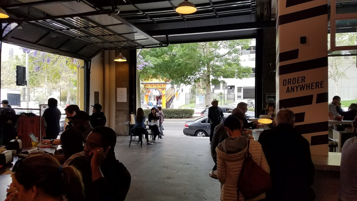
Santa Monica Mountains NRA Total Affiliated Areas This Year: 6 Total Units: 20 My First Official NPS Stamping AdventureAfter returning from Washington D.C. I decided that I wanted to fill up my National Parks Passport as fast as I could. I am a native of Los Angeles and was excited to see that there were some NPS sites in the LA area. I wanted to take advantage of these stamping opportunities while I could since I was planning a move to Eastern Washington for June. I was getting married this summer and my fiance and I had decided to move to her hometown of Spokane, WA. The ticking clock on my time in LA inspired me to get out and see the sites. My fiance and I started our day at the Los Angeles Flower Market where we were looking for some items for an upcoming bridal shower. From here, we decided to explore downtown LA on foot and made our way toward El Pueblo de Los Angeles and Olevra Street. Along the way we paid a visit to the Bradbury Building, originally built in 1893. This building has been used in numerous films and TV shows over the years and features a beautiful atrium filled with ornate staircases and elevators.  We next made our way to the Grand Central Market to grab a drink with my cousin, who lives in downtown. Grand Central Market features a number of food and drink options along with produce and other gifts. We grabbed a beer from Golden Road and took a seat near the opening with a view of the historic Angels Flight Railway. Finally, we arrived at El Pueblo de Los Angeles. El Pueblo and Olvera Street are the oldest areas in LA. El Pueblo was the original settlement of the city of Los Angeles. The Avila Adobe with the oldest home in the area. The historic area features a plaza where the are often dancers and musicians performing. The historic buildings that line the plaza include a winery and a few museum projects. I know they are planning a Mexican food museum, which sounds amazing and will fit perfectly in the area. Opening up to the plaza is the NPS Gateway to Nature office. This was the Park Services' information center for Southern California (UPDATE: I have heard that this office has since closed). We stopped into the Gateway to Nature to pick up a few stamps and get some information about Santa Monica Mountains NRA (my next planned adventure). From here we ventured into Olvera Street and its close gathering of shops and stalls. We made our way to the Avila Adobe and took the self-guided tour of the old dwelling to get a feel for life in early Los Angeles. The woman in the Avila Adobe provided me with the remaining stamps for the location and was excited to talk about the history of the area. When we finished, we made our last stop of the day at Philippe: The Original for a french dip sandwich. This restaurant has claimed to have invented the french dip and is a fun place to eat. They still do things the old fashion way and you really feel like you have stepped back in time while visiting. New Units Visited: 2* Old Spanish NHT - Juan Bautista de Anza NHT Total Affiliated Areas This Year: 5 Total Units: 20 Purpose of this websiteI love to travel and love a good road trip. I enjoy stopping to check out a historical marker or exploring main street in small, remote, towns. When I first discovered the Passport To Your National Parks program, I thought it would be something fun and would maybe get me to finally visit a few National Parks (I had previously visited 16 NPS units over the course of my life). It was when I found the National Park Travelers Club online that I truly fell down the rabbit hole of National Parks stamp collecting. The club's digital maps and archives of stamp locations has inspired me to get out and see out beautiful nation. The NPTC awards programs have motivated me to try and visit at least 25 NPS units this year and to one day, maybe, visit all 418 parks and units. As I visit new places and collect my passport stamps, I will add posts to this site to share my experiences and all the amazing places America has to offer. How it all startedMy journey began at the Ford's Theatre NHS gift shop in Washington D.C. in April of 2018. I was a chaperone on a middle school class trip to D.C. and perusing the gift shop shelves when I came across a small blue book. This blue book was the standard version of the Passport To Your National Parks. This was my third class trip to D.C. so I had not felt the need to buy any souvenirs thus far on the trip and I decided that the passport might be something fun. At the register, the cashier explained how the book work and guided me to the stand featuring what would be my first 3 stamps. I spent the next day flipping through the passport book and doing some Internet research on the program. I had never realized how expansive the National Parks System is and the idea of collecting stamps from all the various locations appealed to me. I love collecting small things as mementos of places I been and events I have attended. I collect ticket stubs and brewery stickers, NPS stamps naturally appealed to me. Conveniently enough, the next day of our class trip took us to Gettysburg National Military Park. I had been to Gettysburg once before, but I was excited to visit again for the historical value and the stamp. As my third trip to D.C., I didn't really see anything new but was glad to discover the National Parks passport program. If only I had stumbled upon the passport at the beginning of my trip, instead of the end, I could have collected a few more stamps! New Units Visited: 3 Ford's Theatre NHS - Pennsylvania Avenue NHS - Gettysburg NMP Total Affiliated Areas This Year: 3 Total Units: 19 |
NPS Units:
|


 RSS Feed
